CommoVision

See the future in real time

Grant County, Kansas

Grant County, Kansas produced 108 Mbbl (thousand barrels) of oil and 16.1 Bcf of natural gas in 2025. 1,798 producing wells tracked, 12 months to Jun 2026.

  • Second-largest gas-producing county in Kansas, 2025.
  • 13.5% of the natural gas produced in Kansas, 2025.
  • Natural gas production fell 5% in 2025 from 2024.
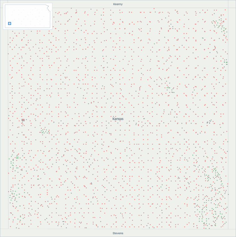
Well map of Grant County, Kansas. The full map is further down this page.

Production

Grant County, Kansas natural gas production (MMcf/d, grouped by when each well first produced)
  • filling in (est. · missed) . Hatching marks our estimate of the volume still to be filed. That estimate draws on our own production forecast. A check on the forecast behind this estimate measured a miss. It updates as filings arrive
Grant County, Kansas natural gas production: million cubic feet per day, by first-production vintage filed in full 255075100 MMcf/d 2017201820192020202120222023202420252026 Dec 2016: 82.2 MMcf/d total Jan 2017: 67.6 MMcf/d total Feb 2017: 67.4 MMcf/d total Mar 2017: 66.7 MMcf/d total Apr 2017: 64.9 MMcf/d total May 2017: 65.2 MMcf/d total Jun 2017: 67.8 MMcf/d total Jul 2017: 67.1 MMcf/d total Aug 2017: 66.6 MMcf/d total Sep 2017: 66 MMcf/d total Oct 2017: 65 MMcf/d total Nov 2017: 64.1 MMcf/d total Dec 2017: 63 MMcf/d total Jan 2018: 63.6 MMcf/d total Feb 2018: 64 MMcf/d total Mar 2018: 60.3 MMcf/d total Apr 2018: 62.8 MMcf/d total May 2018: 61.6 MMcf/d total Jun 2018: 56.1 MMcf/d total Jul 2018: 62.6 MMcf/d total Aug 2018: 60.9 MMcf/d total Sep 2018: 62.7 MMcf/d total Oct 2018: 62.6 MMcf/d total Nov 2018: 61 MMcf/d total Dec 2018: 56.2 MMcf/d total Jan 2019: 59.1 MMcf/d total Feb 2019: 58.6 MMcf/d total Mar 2019: 58.8 MMcf/d total Apr 2019: 59 MMcf/d total May 2019: 51.6 MMcf/d total Jun 2019: 59.5 MMcf/d total Jul 2019: 59.2 MMcf/d total Aug 2019: 58.5 MMcf/d total Sep 2019: 58.4 MMcf/d total Oct 2019: 57.6 MMcf/d total Nov 2019: 57.2 MMcf/d total Dec 2019: 57.2 MMcf/d total Jan 2020: 56.9 MMcf/d total Feb 2020: 57 MMcf/d total Mar 2020: 56 MMcf/d total Apr 2020: 56.7 MMcf/d total May 2020: 57.2 MMcf/d total Jun 2020: 56.4 MMcf/d total Jul 2020: 56.8 MMcf/d total Aug 2020: 56.1 MMcf/d total Sep 2020: 54.9 MMcf/d total Oct 2020: 55.2 MMcf/d total Nov 2020: 54.5 MMcf/d total Dec 2020: 54.3 MMcf/d total Jan 2021: 54 MMcf/d total Feb 2021: 45.8 MMcf/d total Mar 2021: 55.9 MMcf/d total Apr 2021: 56.5 MMcf/d total May 2021: 53.3 MMcf/d total Jun 2021: 54.6 MMcf/d total Jul 2021: 54.5 MMcf/d total Aug 2021: 53.8 MMcf/d total Sep 2021: 53.2 MMcf/d total Oct 2021: 53.1 MMcf/d total Nov 2021: 53.1 MMcf/d total Dec 2021: 52.4 MMcf/d total Jan 2022: 50.3 MMcf/d total Feb 2022: 49.8 MMcf/d total Mar 2022: 50.3 MMcf/d total Apr 2022: 51.7 MMcf/d total May 2022: 51.1 MMcf/d total Jun 2022: 51.6 MMcf/d total Jul 2022: 51 MMcf/d total Aug 2022: 51.7 MMcf/d total Sep 2022: 46.9 MMcf/d total Oct 2022: 53.2 MMcf/d total Nov 2022: 51 MMcf/d total Dec 2022: 47.8 MMcf/d total Jan 2023: 48.6 MMcf/d total Feb 2023: 49.8 MMcf/d total Mar 2023: 49.4 MMcf/d total Apr 2023: 49.8 MMcf/d total May 2023: 49.7 MMcf/d total Jun 2023: 47.2 MMcf/d total Jul 2023: 49.3 MMcf/d total Aug 2023: 48.9 MMcf/d total Sep 2023: 49.3 MMcf/d total Oct 2023: 49.7 MMcf/d total Nov 2023: 49.2 MMcf/d total Dec 2023: 48.5 MMcf/d total Jan 2024: 43.9 MMcf/d total Feb 2024: 48.1 MMcf/d total Mar 2024: 47.1 MMcf/d total Apr 2024: 47 MMcf/d total May 2024: 47.6 MMcf/d total Jun 2024: 47.1 MMcf/d total Jul 2024: 46.6 MMcf/d total Aug 2024: 45.9 MMcf/d total Sep 2024: 46 MMcf/d total Oct 2024: 45.7 MMcf/d total Nov 2024: 44.5 MMcf/d total Dec 2024: 45.1 MMcf/d total Jan 2025: 43.6 MMcf/d total Feb 2025: 42.3 MMcf/d total Mar 2025: 44.9 MMcf/d total Apr 2025: 42.2 MMcf/d total May 2025: 46.1 MMcf/d total Jun 2025: 44.6 MMcf/d total Jul 2025: 45.2 MMcf/d total Aug 2025: 44.9 MMcf/d total Sep 2025: 44.3 MMcf/d total Oct 2025: 44.3 MMcf/d total Nov 2025: 44.2 MMcf/d total Dec 2025: 42.8 MMcf/d total Jan 2026: 40.2 MMcf/d total Feb 2026: 42.9 MMcf/d total Mar 2026: 42.3 MMcf/d total Apr 2026: ≈41.3 MMcf/d total (100% arrived, remainder estimated) May 2026: ≈40.4 MMcf/d total (99% arrived, remainder estimated) Jun 2026: ≈42.3 MMcf/d total (99% arrived, remainder estimated) Jul 2026: ≈41.5 MMcf/d total (<1% arrived, remainder estimated) Aug 2026: ≈41.2 MMcf/d total (<1% arrived, remainder estimated) Sep 2026: ≈40.9 MMcf/d total (<1% arrived, remainder estimated) Oct 2026: ≈40.7 MMcf/d total (<1% arrived, remainder estimated) Nov 2026: ≈40.7 MMcf/d total (<1% arrived, remainder estimated)

All from what the source published. All held at well grain.

How the volume breaks down
  • 99.05% Reported by the official source by well
  • 0.95% Reported by the official source as a lease total, split across the lease's wells. The regional total shown is the reported number, to rounding.

Every cubic foot through March 2026 starts from what the official source published for those months. Measured over January 1987 to March 2026.

Grant County, Kansas oil production (bbl/d, grouped by when each well first produced)
  • filling in (est. · missed) . Hatching marks our estimate of the volume still to be filed. That estimate draws on our own production forecast. A check on the forecast behind this estimate measured a miss. It updates as filings arrive
Grant County, Kansas oil production: barrels per day, by first-production vintage filed in full 5001,0001,5002,0002,500 bbl/d 2017201820192020202120222023202420252026 Dec 2016: 1,988 bbl/d total Jan 2017: 1,957 bbl/d total Feb 2017: 1,900 bbl/d total Mar 2017: 1,779 bbl/d total Apr 2017: 1,695 bbl/d total May 2017: 1,683 bbl/d total Jun 2017: 1,656 bbl/d total Jul 2017: 1,591 bbl/d total Aug 2017: 1,498 bbl/d total Sep 2017: 1,371 bbl/d total Oct 2017: 1,357 bbl/d total Nov 2017: 1,462 bbl/d total Dec 2017: 1,280 bbl/d total Jan 2018: 1,260 bbl/d total Feb 2018: 1,282 bbl/d total Mar 2018: 1,328 bbl/d total Apr 2018: 1,296 bbl/d total May 2018: 1,227 bbl/d total Jun 2018: 1,242 bbl/d total Jul 2018: 1,225 bbl/d total Aug 2018: 1,136 bbl/d total Sep 2018: 1,091 bbl/d total Oct 2018: 1,009 bbl/d total Nov 2018: 1,068 bbl/d total Dec 2018: 1,057 bbl/d total Jan 2019: 1,176 bbl/d total Feb 2019: 1,021 bbl/d total Mar 2019: 959 bbl/d total Apr 2019: 933 bbl/d total May 2019: 935 bbl/d total Jun 2019: 951 bbl/d total Jul 2019: 893 bbl/d total Aug 2019: 891 bbl/d total Sep 2019: 904 bbl/d total Oct 2019: 862 bbl/d total Nov 2019: 849 bbl/d total Dec 2019: 774 bbl/d total Jan 2020: 686 bbl/d total Feb 2020: 620 bbl/d total Mar 2020: 661 bbl/d total Apr 2020: 640 bbl/d total May 2020: 545 bbl/d total Jun 2020: 647 bbl/d total Jul 2020: 584 bbl/d total Aug 2020: 577 bbl/d total Sep 2020: 588 bbl/d total Oct 2020: 571 bbl/d total Nov 2020: 570 bbl/d total Dec 2020: 579 bbl/d total Jan 2021: 549 bbl/d total Feb 2021: 547 bbl/d total Mar 2021: 578 bbl/d total Apr 2021: 580 bbl/d total May 2021: 501 bbl/d total Jun 2021: 447 bbl/d total Jul 2021: 472 bbl/d total Aug 2021: 427 bbl/d total Sep 2021: 454 bbl/d total Oct 2021: 443 bbl/d total Nov 2021: 416 bbl/d total Dec 2021: 410 bbl/d total Jan 2022: 400 bbl/d total Feb 2022: 369 bbl/d total Mar 2022: 332 bbl/d total Apr 2022: 356 bbl/d total May 2022: 386 bbl/d total Jun 2022: 375 bbl/d total Jul 2022: 375 bbl/d total Aug 2022: 368 bbl/d total Sep 2022: 394 bbl/d total Oct 2022: 438 bbl/d total Nov 2022: 433 bbl/d total Dec 2022: 421 bbl/d total Jan 2023: 410 bbl/d total Feb 2023: 351 bbl/d total Mar 2023: 382 bbl/d total Apr 2023: 400 bbl/d total May 2023: 334 bbl/d total Jun 2023: 354 bbl/d total Jul 2023: 309 bbl/d total Aug 2023: 325 bbl/d total Sep 2023: 297 bbl/d total Oct 2023: 328 bbl/d total Nov 2023: 298 bbl/d total Dec 2023: 262 bbl/d total Jan 2024: 303 bbl/d total Feb 2024: 328 bbl/d total Mar 2024: 268 bbl/d total Apr 2024: 288 bbl/d total May 2024: 315 bbl/d total Jun 2024: 257 bbl/d total Jul 2024: 271 bbl/d total Aug 2024: 287 bbl/d total Sep 2024: 258 bbl/d total Oct 2024: 277 bbl/d total Nov 2024: 250 bbl/d total Dec 2024: 262 bbl/d total Jan 2025: 272 bbl/d total Feb 2025: 244 bbl/d total Mar 2025: 258 bbl/d total Apr 2025: 253 bbl/d total May 2025: 302 bbl/d total Jun 2025: 353 bbl/d total Jul 2025: 356 bbl/d total Aug 2025: 297 bbl/d total Sep 2025: 310 bbl/d total Oct 2025: 313 bbl/d total Nov 2025: 262 bbl/d total Dec 2025: 320 bbl/d total Jan 2026: 372 bbl/d total Feb 2026: 313 bbl/d total Mar 2026: 267 bbl/d total Apr 2026: ≈313 bbl/d total (100% arrived, remainder estimated) May 2026: ≈225 bbl/d total (99% arrived, remainder estimated) Jun 2026: ≈302 bbl/d total (99% arrived, remainder estimated) Jul 2026: ≈238 bbl/d total (<1% arrived, remainder estimated) Aug 2026: ≈253 bbl/d total (<1% arrived, remainder estimated) Sep 2026: ≈253 bbl/d total (<1% arrived, remainder estimated) Oct 2026: ≈251 bbl/d total (<1% arrived, remainder estimated) Nov 2026: ≈250 bbl/d total (<1% arrived, remainder estimated)

All from what the source published. All held at well grain.

How the volume breaks down
  • 39.0% Reported by the official source by well
  • 61.0% Reported by the official source as a lease total, split across the lease's wells. The regional total shown is the reported number, to rounding.

Every barrel through March 2026 starts from what the official source published for those months. Measured over January 1987 to March 2026.

The bands group wells by when they first produced.

About this chart

The stack shows what is holding today's rate up and how much of it is new drilling. In the reported months the bands draw the filings already in. The months still filling in are marked.

Annual table (full history)

best estimate incl. allocated

YearOil (MMbbl)Gas produced (Bcf)
20250.116
20240.117
20230.118
20220.118
20210.219
20200.220
20190.321
20180.422
20170.624
20160.726
20150.331
20140.229
20130.229
20120.330
20110.332
20100.435
20090.737
20080.439
20070.240
20060.344
20050.448
20040.552
20030.657
20020.463
20010.368
20000.377
19990.385
19980.393
19970.4111
19960.5120
19950.6125
19940.6126
19930.9111
19921.1104
19911.3115
19900.8106
19890.3100
19880.2103
19870.268

Source: CommoVision (commovision.com)

Monthly table (last 24 months)
MonthOil (Mbbl)Gas produced (MMcf)
2026-068.81,253
2026-056.81,244
2026-049.41,238
2026-038.31,312
2026-028.81,201
2026-0111.51,246
2025-129.91,326
2025-117.91,326
2025-109.71,373
2025-099.31,328
2025-089.21,393
2025-0711.01,401
2025-0610.61,337
2025-059.41,429
2025-047.61,267
2025-038.01,391
2025-026.81,186
2025-018.41,352
2024-128.11,398
2024-117.51,334
2024-108.61,416
2024-097.71,381
2024-088.91,423
2024-078.41,446

Source: CommoVision (commovision.com)

Source: CommoVision · Grant County, Kansas, data through June 2026.

Well map

A map of 2,590 well locations in Grant County, Kansas for which CommoVision holds a published surface coordinate, each drawn where it is and colored by its primary product (green for oil, red for natural gas, gray where undetermined; a spot shared by more than one product shows the one with the most wells there), on a ground of land and water over faint county outlines and place names for orientation, with a small inset map locating this frame in Kansas.
  • Oil 194
  • Natural gas 2,015
  • Undetermined 381
2,590 well locations in Grant County, Kansas, colored by primary product.
About this map

Undetermined means not enough signal to settle it. Producing wells are the ones that reported oil or gas in the 12 months to Jun 2026.

302.3 bbl/d (est.) Jun 2026 oil production Jun 2026 is still filling in. The figure is the filings already in plus an estimate of the part not yet filed. The change compares this estimate with the same month last year. -14.5% vs Jun last year best estimate incl. allocated
42.3 MMcf/d (est.) Jun 2026 gas production Jun 2026 is still filling in. The figure is the filings already in plus an estimate of the part not yet filed. The change compares this estimate with the same month last year. -5.1% vs Jun last year
295.7 bbl/d 2025 oil production best estimate incl. allocated
44.1 MMcf/d 2025 gas production
1,798 wells Producing wells tracked 12 months to Jun 2026

Type curves

Grant County, Kansas natural gas type curves (Mcf/d per well, log scale, against months on production; cohorts 2010–2022)
Grant County, Kansas natural gas type curves: average thousand cubic feet per day per well on a log scale against months on production 2010-2014: 66 wells in curve; starts at 141 Mcf/d per well, 0.2 Bcf cumulative through month 139 (100% of its wells old enough at that month); the dashed curve runs through month 199, on our forecast where a well’s own record ends2015: 25 wells in curve; starts at 66.9 Mcf/d per well, 0.1 Bcf cumulative through month 132 (100% of its wells old enough at that month); the dashed curve runs through month 192, on our forecast where a well’s own record ends2016: 6 wells in curve; starts at 1.7 Mcf/d per well, 0.0 Bcf cumulative through month 59 (100% of its wells old enough at that month); the dashed curve runs through month 178, on our forecast where a well’s own record ends2017: 9 wells in curve; starts at 16.1 Mcf/d per well, 0.0 Bcf cumulative through month 59 (100% of its wells old enough at that month)2022: 8 wells in curve; starts at 55.8 Mcf/d per well, 0.1 Bcf cumulative through month 46 (100% of its wells old enough at that month); the dashed curve runs through month 106, on our forecast where a well’s own record ends0.1110100200Mcf/d24487296120144168192216Months on production
Grant County, Kansas oil type curves (bbl/d per well, log scale, against months on production; cohorts 2010–2022)
Grant County, Kansas oil type curves: average barrels per day per well on a log scale against months on production 2010-2014: 66 wells in curve; starts at 0.2 bbl/d per well, 1.1 Mbbl cumulative through month 139 (100% of its wells old enough at that month); the dashed curve runs through month 199, on our forecast where a well’s own record ends2015: 25 wells in curve; starts at 4.5 bbl/d per well, 16.9 Mbbl cumulative through month 132 (100% of its wells old enough at that month); the dashed curve runs through month 192, on our forecast where a well’s own record ends2016: 6 wells in curve; starts at 44.9 bbl/d per well, 66.5 Mbbl cumulative through month 118 (100% of its wells old enough at that month); the dashed curve runs through month 178, on our forecast where a well’s own record ends2017: 9 wells in curve; starts at 47.9 bbl/d per well, 48.4 Mbbl cumulative through month 105 (100% of its wells old enough at that month); the dashed curve runs through month 165, on our forecast where a well’s own record ends2022: 8 wells in curve; starts at 0.1 bbl/d per well, 1.1 Mbbl cumulative through month 46 (100% of its wells old enough at that month); the dashed curve runs through month 106, on our forecast where a well’s own record ends0.1110100150bbl/d24487296120144168192216Months on production

best estimate incl. allocated

Average production per well, for wells grouped by when they first produced.

How these curves are built

Average daily production per well, for wells grouped by when they first produced. Includes every well of the cohort that is old enough at each month. Wells that are shut in or have stopped producing count as zero, so the average reflects the full cohort, not just survivors. Rates are calendar-day (volume ÷ days in month). The cumulative axis accumulates those same monthly averages at the average month length. Months not yet fully reported are excluded. The 2010-2014 curve draws those years as one group. The chart opens on average daily rate against months on production, the rate on a log scale. The view control switches to rate against cumulative production per well, on the same log rate scale, or to cumulative production per well against months on production, on a linear scale. Every view draws the same cohorts from the same production history. Each cohort with a dashed curve is solid through the last month all the wells in its curve sit inside fully reported data. Past it the dashed curve carries the same wells forward, on our forecast where a well’s own record ends, for up to five years. A dashed curve runs as far as at least nine in ten of its wells are accounted for. A cohort with no dashed curve is drawn only through the months where at least 50% of its wells are old enough for the month to be fully reported. A well that is old enough but shut in still counts, as zero. The measured months are what these wells reported. In the forward months each well counts its own reported figure for each month it has one, our forecast for each month it has only that, and zero for the rest. The forward average counts every well in the curve. The drawn forecast runs up to five years past the measured months. Line thickness tracks how many wells each curve is drawn from. 1,430 wells are counted here but not shown on the age axis: they started producing in 1989 or earlier, too close to the start of our records for their region to verify their true age.

Cohort summary table
First produced Wells in curve Peak oil (bbl/d per well) Month-12 oil (bbl/d per well) Cum oil in series (Mbbl per well) Peak gas (Mcf/d per well) Month-12 gas (Mcf/d per well) Cum gas in series (Bcf per well) Months in series Wells old enough at last month in series Forecast months drawn
2022 8 2 1.4 1.1 129 50.8 0.1 46 100% 60
2017 9 49.9 46.9 48.4 16.1 2.3 0.0 106 78% 60
2016 6 140 91 66.5 36.3 32.2 0.0 118 100% 60
2015 25 14.9 8.8 16.9 89.4 38.5 0.1 132 100% 60
2010-2014 66 0.6 0.5 1.1 185 94.1 0.2 139 100% 60

Source: CommoVision (commovision.com)

Source: CommoVision · Grant County, Kansas type curves, per-well production by first-production cohort.

Top operators in Grant County, Kansas, 2025 best estimate incl. allocated

  1. Scout Energy Management 64.3%
  2. Merit Energy Company 27.3%
  3. Pantera Energy Company 3.8%
  4. Eiger Operating Company, LLC 1.8%
  5. H & B Petroleum Corp. 0.4%
  6. Becker Oil Corporation 0.4%
  7. Mach Natural Resources LP 0.3%
  8. Kansas Natural Gas Operating, Lc 0.2%
  9. Greenhead Energy Operating LLC 0.2%
  10. Occidental Petroleum 0.2%
  11. 6 other operators 0.6%
  12. Without a named operator 0.5%
Top operators in Grant County, Kansas, 2025: full table
OperatorOil (Mbbl/d, 2025)Gas produced (MMcf/d, 2025)Share of output
Scout Energy Management 0.031.264.3%
Merit Energy Company 0.111.527.3%
Pantera Energy Company 0.10.03.8%
Eiger Operating Company, LLC 0.00.71.8%
H & B Petroleum Corp. 0.00.00.4%
Becker Oil Corporation 0.00.00.4%
Mach Natural Resources LP 0.00.00.3%
Kansas Natural Gas Operating, Lc 0.00.10.2%
Greenhead Energy Operating LLC 0.00.00.2%
Occidental Petroleum 0.00.10.2%
6 other operators 0.00.30.6%
Without a named operator 0.00.20.5%

Mbbl/d = thousand barrels per day · MMcf/d = million cubic feet per day (units).

Source: CommoVision (commovision.com)

What we cover here

Each row names the grain a region’s production is held at. Where a source publishes at a coarser grain, the page says so.

DataGrainSinceBenchmark
Kansas production well 1987-01 ~99% of EIA

Benchmark cells compare our series with the EIA’s published estimates.

About the EIA comparison

The two are produced differently: the EIA estimates from a survey of the largest operators and a model built to anticipate late filings, while the series compared here are rebuilt from official records as they arrive. Recent months can differ without either being wrong; the methodology page explains both methods.

Coverage rows for Grant County, Kansas are regenerated at every build from the same catalog of sources the data is built from.

What the data shows

  • Grant County, Kansas produced 108 Mbbl (thousand barrels) of oil and 16.1 Bcf of natural gas in 2025.
  • Grant County, Kansas gas production peaked in 1994 at 125.7 Bcf; 2025 output of 16.1 Bcf ran at 13% of that peak.
  • 1,798 producing wells tracked, 12 months to Jun 2026.

Start a free trial

Watch supply move as soon as its sources publish, with forecasts on 1.1+ million producing wells. A real API and MCP access for AI tools are live, and the Portal is open.

What the trial includes

Data use is subject to our Terms of Service.