
Carter County, Oklahoma
Carter County, Oklahoma produced 10.0 MMbbl of oil and 86.0 Bcf of natural gas in 2025. 2,080 producing wells tracked, 12 months to Aug 2026.
- Fourth-largest oil-producing county in Oklahoma, 2025.
- 6.7% of the oil produced in Oklahoma, 2025.
- Oil production rose 5% in 2025 from 2024.
Production
- filling in (est. · missed) . Hatching marks our estimate of the volume still to be filed. That estimate draws on our own production forecast. A check on the forecast behind this estimate measured a miss. It updates as filings arrive
All from what the source published. 29.4% held at well grain.
How the volume breaks down
- 17.5% Reported by the official source by well
- 70.6% Reported by the official source as a lease, facility, field or state total. Published without per-well detail.
- 11.8% Reported by the official source as a lease total, split across the lease's wells. The regional total shown is the reported number, to rounding.
Every barrel through May 2026 starts from what the official source published for those months. Measured over January 1990 to May 2026.
The gray “without per-well detail” band is volume the source reports above the well: fields, facilities, or leases the source publishes as one total. It is included so the stack still sums to the whole entity.
- filling in (est. · missed) . Hatching marks our estimate of the volume still to be filed. That estimate draws on our own production forecast. A check on the forecast behind this estimate measured a miss. It updates as filings arrive
All from what the source published. 88.9% held at well grain.
How the volume breaks down
- 72.9% Reported by the official source by well
- 11.1% Reported by the official source as a lease, facility, field or state total. Published without per-well detail.
- 16.0% Reported by the official source as a lease total, split across the lease's wells. The regional total shown is the reported number, to rounding.
Every cubic foot through May 2026 starts from what the official source published for those months. Measured over January 1990 to May 2026.
The gray “without per-well detail” band is volume the source reports above the well: fields, facilities, or leases the source publishes as one total. It is included so the stack still sums to the whole entity.
The bands group wells by when they first produced.
About this chart
The stack shows what is holding today's rate up and how much of it is new drilling. In the reported months the bands draw the filings already in. The months still filling in are marked.
Annual table (full history)
best estimate incl. unsplit totals and allocated
| Year | Oil (MMbbl) | Gas produced (Bcf) |
|---|---|---|
| 2025 | 10.0 | 86 |
| 2024 | 9.5 | 60 |
| 2023 | 10.4 | 66 |
| 2022 | 8.0 | 61 |
| 2021 | 6.9 | 47 |
| 2020 | 6.5 | 39 |
| 2019 | 7.0 | 39 |
| 2018 | 7.3 | 43 |
| 2017 | 8.2 | 51 |
| 2016 | 7.4 | 41 |
| 2015 | 8.6 | 50 |
| 2014 | 8.9 | 53 |
| 2013 | 8.3 | 41 |
| 2012 | 8.1 | 32 |
| 2011 | 8.3 | 28 |
| 2010 | 7.5 | 24 |
| 2009 | 6.9 | 19 |
| 2008 | 7.2 | 15 |
| 2007 | 7.4 | 14 |
| 2006 | 6.9 | 16 |
| 2005 | 7.0 | 15 |
| 2004 | 7.1 | 15 |
| 2003 | 7.5 | 15 |
| 2002 | 7.7 | 15 |
| 2001 | 7.8 | 17 |
| 2000 | 8.2 | 18 |
| 1999 | 4.1 | 19 |
| 1998 | 4.4 | 20 |
| 1997 | 12.0 | 18 |
| 1996 | 11.2 | 19 |
| 1995 | 11.5 | 17 |
| 1994 | 11.8 | 19 |
| 1993 | 12.4 | 20 |
| 1992 | 13.4 | 20 |
| 1991 | 14.6 | 23 |
| 1990 | 7.5 | 10 |
Source: CommoVision (commovision.com)
Monthly table (last 24 months)
| Month | Oil (Mbbl) | Gas produced (MMcf) |
|---|---|---|
| 2026-08 | 880.6 | 7,533 |
| 2026-07 | 971.0 | 7,259 |
| 2026-06 | 741.9 | 5,483 |
| 2026-05 | 641.6 | 5,639 |
| 2026-04 | 638.3 | 5,762 |
| 2026-03 | 692.2 | 6,493 |
| 2026-02 | 653.3 | 6,369 |
| 2026-01 | 718.0 | 8,082 |
| 2025-12 | 796.8 | 8,377 |
| 2025-11 | 760.1 | 7,380 |
| 2025-10 | 773.7 | 7,399 |
| 2025-09 | 736.4 | 6,828 |
| 2025-08 | 766.9 | 6,861 |
| 2025-07 | 809.2 | 7,194 |
| 2025-06 | 812.9 | 6,456 |
| 2025-05 | 801.4 | 7,037 |
| 2025-04 | 854.3 | 6,831 |
| 2025-03 | 922.2 | 6,834 |
| 2025-02 | 924.1 | 8,167 |
| 2025-01 | 995.6 | 6,666 |
| 2024-12 | 1,182.6 | 6,361 |
| 2024-11 | 954.6 | 4,707 |
| 2024-10 | 723.1 | 4,277 |
| 2024-09 | 658.6 | 3,985 |
Source: CommoVision (commovision.com)
Source: CommoVision · Carter County, Oklahoma, data through October 2026.
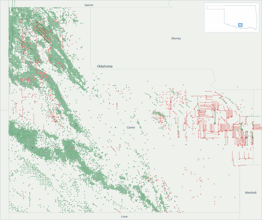
Well map
- Oil 13,323
- Natural gas 1,572
- Undetermined 4,516
About this map
Undetermined means not enough signal to settle it. Producing wells are the ones that reported oil or gas in the 12 months to Aug 2026.
Type curves
4 of the drawn cohorts’ wells are not in these curves yet: each is still producing and joins its curve once it carries a forecast.
4 of the drawn cohorts’ wells are not in these curves yet: each is still producing and joins its curve once it carries a forecast.
best estimate incl. allocated
Horizontal wells only. Average production per well, for wells grouped by when they first produced.
How these curves are built
Horizontal wells only: 341 of the 716 wells in these cohorts. Average daily production per well, for wells grouped by when they first produced. Includes every well of the cohort that is old enough at each month, except wells that are still active but not yet covered by our forecasts; those are left out of both the reported and forecast parts until they are. Wells that are shut in or have stopped producing count as zero, so the average reflects the whole group drawn, not just survivors. Rates are calendar-day (volume ÷ days in month). The cumulative axis accumulates those same monthly averages at the average month length. Months not yet fully reported are excluded. The 2010-2014 curve draws those years as one group. The chart opens on average daily rate against months on production, the rate on a log scale. The view control switches to rate against cumulative production per well, on the same log rate scale, or to cumulative production per well against months on production, on a linear scale. Every view draws the same cohorts from the same production history. Each cohort is solid through the last month all the wells in its curve sit inside fully reported data. Past it the dashed curve carries the same wells forward, on our forecast where a well’s own record ends, for up to five years. A dashed curve runs as far as at least nine in ten of its wells are accounted for. A well that is old enough but shut in still counts, as zero. The measured months are what these wells reported. In the forward months each well counts its own reported figure for each month it has one, our forecast for each month it has only that, and zero for the rest. The forward average counts every well in the curve. The drawn forecast runs up to five years past the measured months. Line thickness tracks how many wells each curve is drawn from. 5 wells are counted here but not shown on the age axis: they started producing in 1992 or earlier, too close to the start of our records for their region to verify their true age.
Cohort summary table
| First produced | Wells in curve | Peak oil (bbl/d per well) | Month-12 oil (bbl/d per well) | Cum oil in series (Mbbl per well) | Peak gas (Mcf/d per well) | Month-12 gas (Mcf/d per well) | Cum gas in series (Bcf per well) | Months in series | Wells old enough at last month in series | Forecast months drawn |
|---|---|---|---|---|---|---|---|---|---|---|
| 2026 | 15 | 733 | — | 31.1 | 2,957 | — | 0.1 | 2 | 100% | 60 |
| 2025 | 20 | 343 | — | 67.1 | 3,340 | — | 0.8 | 10 | 100% | 60 |
| 2024 | 21 | 818 | 220 | 209 | 4,176 | 3,137 | 1.7 | 22 | 100% | 60 |
| 2023 | 19 | 1,165 | 255 | 301 | 4,477 | 2,781 | 2.5 | 35 | 100% | 60 |
| 2022 | 8 | 439 | 184 | 178 | 2,416 | 1,933 | 1.8 | 45 | 100% | 60 |
| 2021 | 28 | 332 | 141 | 151 | 3,139 | 2,668 | 2.8 | 57 | 100% | 60 |
| 2019 | 8 | 232 | 232 | 141 | 2,203 | 2,203 | 2.2 | 81 | 100% | 60 |
| 2017 | 25 | 133 | 49.7 | 65.2 | 1,309 | 885 | 1.5 | 105 | 100% | 60 |
| 2016 | 6 | 135 | 50.5 | 73.1 | 3,995 | 2,115 | 4.0 | 118 | 100% | 60 |
| 2015 | 21 | 164 | 44.5 | 81.7 | 1,297 | 336 | 1.6 | 134 | 100% | 60 |
| 2010-2014 | 166 | 102 | 39.3 | 59.5 | 1,578 | 789 | 1.7 | 141 | 100% | 60 |
Source: CommoVision (commovision.com)
Source: CommoVision · Carter County, Oklahoma type curves, per-well production by first-production cohort.
Top operators in Carter County, Oklahoma, 2025 best estimate incl. unsplit totals and allocated
Top operators in Carter County, Oklahoma, 2025: full table
| Operator | Oil (Mbbl/d, 2025) | Gas produced (MMcf/d, 2025) | Share of output |
|---|---|---|---|
| Continental Resources | 9.5 | 137.7 | 43.4% |
| Citation Oil & Gas Corp. | 6.6 | 15.7 | 17.8% |
| XTO Energy | 3.0 | 62.2 | 16.7% |
| Kolibri Energy US | 1.1 | 1.0 | 2.8% |
| Mack Energy Corporation | 0.8 | 0.8 | 2.0% |
| Scout Energy Management | 0.8 | 0.0 | 1.9% |
| Black Mesa Energy | 0.5 | 4.1 | 1.8% |
| Coronado Energy Partners LLC | 0.7 | 1.8 | 1.8% |
| Kodiak Oil & Gas, Inc. | 0.8 | 0.0 | 1.8% |
| Mach Natural Resources LP | 0.3 | 4.9 | 1.5% |
| 126 other operators | 2.9 | 7.4 | 7.8% |
| Without a named operator | 0.3 | 0.1 | 0.6% |
Mbbl/d = thousand barrels per day · MMcf/d = million cubic feet per day (units).
Source: CommoVision (commovision.com)
Active drilling rigs
Interactive chart. Focus it and use the left and right arrow keys to read each week, Page Up and Page Down to move a year, Home and End for the ends of the series. The full figures are also in the table below.
- In Carter County, Oklahoma, 2 drilling rigs were active in the week to November 6, 2026 (unchanged from a year earlier).
- Since Nov 2016, the weekly count peaked at 7 in May 2024.
- The count covers land and inland-water rigs; rigs in US federal offshore waters are counted on the Gulf of Mexico page.
Average active rigs per month: full table
| Month | Oil-directed | Gas-directed | All rigs |
|---|---|---|---|
| Nov 2026 (through November 6, 2026) | 2 | 0 | 2 |
| Oct 2026 | 2 | 0 | 2 |
| Sep 2026 | 2 | 0 | 2 |
| Aug 2026 | 2 | 0 | 2 |
| Jul 2026 | 2 | 0 | 2 |
| Jun 2026 | 2 | 0 | 2 |
| May 2026 | 2 | 0 | 2 |
| Apr 2026 | 1 | 0 | 1 |
| Mar 2026 | 0.8 | 0 | 0.8 |
| Feb 2026 | 2 | 0 | 2 |
| Jan 2026 | 3.5 | 0 | 3.5 |
| Dec 2025 | 3.8 | 0 | 3.8 |
| Nov 2025 | 2.8 | 0 | 2.8 |
| Oct 2025 | 2 | 0 | 2 |
| Sep 2025 | 0.6 | 0 | 0.6 |
| Aug 2025 | 1 | 0 | 1 |
| Jul 2025 | 1 | 0 | 1 |
| Jun 2025 | 2.8 | 0 | 2.8 |
| May 2025 | 3.5 | 0 | 3.5 |
| Apr 2025 | 4.5 | 0 | 4.5 |
| Mar 2025 | 4.2 | 0 | 4.2 |
| Feb 2025 | 2.5 | 0 | 2.5 |
| Jan 2025 | 0.5 | 0 | 0.5 |
| Dec 2024 | 0 | 0 | 0 |
Source: CommoVision (commovision.com)
What we cover here
Each row names the grain a region’s production is held at. Where a source publishes at a coarser grain, the page says so.
| Data | Grain | Since | Benchmark |
|---|---|---|---|
| Oklahoma production | lease + well | 1990-07 | ~99–100% of EIA |
Benchmark cells compare our series with the EIA’s published estimates.
About the EIA comparison
The two are produced differently: the EIA estimates from a survey of the largest operators and a model built to anticipate late filings, while the series compared here are rebuilt from official records as they arrive. Recent months can differ without either being wrong; the methodology page explains both methods.
Coverage rows for Carter County, Oklahoma are regenerated at every build from the same catalog of sources the data is built from.
What the data shows
- Carter County, Oklahoma produced 10.0 MMbbl of oil and 86.0 Bcf of natural gas in 2025.
- Carter County, Oklahoma oil production peaked in 1991 at 14.6 MMbbl; 2025 output of 10.0 MMbbl ran at 68% of that peak.
- 2,080 producing wells tracked, 12 months to Aug 2026.
Start a free trial
Watch supply move as soon as its sources publish, with forecasts on 1.1+ million producing wells. A real API and MCP access for AI tools are live, and the Portal is open.
Data use is subject to our Terms of Service.